Features
A message from the Deep Dive founder

I created Deep Dive Intelligence to provide in-depth news and insights about the technologies and policy debates that are so fundamental to America’s future. It’s been a year of important work, but now Deep Dive has arrived at a crossroads.

Deep Dive Founder Ben Iannotta
I have accepted the position of editor-in-chief of Aerospace America, the magazine of the American Institute of Aeronautics and Astronautics. I’m excited by the magazine's mission of informing aerospace professionals about the issues that are critical to their profession. As for Deep Dive, my hope is that a journalist or media company will emerge to take up the endeavor. In the meantime, Deep Dive will not be posting any new articles or content, although the existing content will remain available online for some period of time.
I want to thank each of you for reading Deep Dive, sharing articles, commenting on them and suggesting ideas for future coverage.
Sincerely,
Ben Iannotta
Founding Editor
Test your analytic skills

Can you tell what you’re looking at in this long-range radar image? See the answer below.

Mystery picture: Inverse synthetic aperture radar image (Credit: Raytheon)
This is a frigate seen in an inverse synthetic aperture radar image. To generate ISAR images like these, the radars on maritime surveillance planes stop scanning to focus on specific objects. Doppler shifts in the radar reflections are collected as the objects move across the sea. Software turns those readings into images and automatically classifies the objects based on their lengths and features. “ISAR allows you to tell whether it’s a combatant ship or fishing vessel or a cargo ship, and you can do it at significant ranges – 50, 60, 70 miles,” says Raytheon’s Brad Hopper, senior business development manager for intelligence, surveillance and reconnaissance.
Raytheon recently demonstrated automated ISAR for Australian customs officials as part of a software upgrade the company hopes to convince them to undertake. Today, Raytheon SeaVue radars scan Australian coastal waters from Dash 8 turboprops flown by Cobham under an initiative called Project Sentinel. In the demo, Raytheon upgraded a Dash 8 radar to the SeaVue XMC software configuration, short for Expanded Mission Capability. SeaVue XMC automatically detects and tracks thousands of targets for operators, instead of today's 100 or 200, and can automatically focus in on the most suspicious of them using the ISAR mode, Hopper says.
Explaining Activity-Based Intel

BAE does a brisk business providing software tools to intelligence analysts and contracting out analysts to various U.S. intel agencies. Jordan Becker is general manager of that business. BAE counts itself as a pioneer in the relatively new field of Activity-Based Intelligence, in which specialized software rifles through volumes of data to help analysts figure out what kind of activities people spotted in a video image or overheard on a cellular call are engaged in. In December, BAE received a $60 million contract from NGA to deliver ABI software tools and computing infrastructure. Becker, an electrical engineer by training, wasn’t always the analysis expert he is today. While at IBM in the 1990s, he helped pioneer email services through a spin-off company IBM sold to America Online in 1994. I spoke by phone with Becker about the future of Activity-Based Intelligence.

BAE's Jordan Becker
ABI defined >> “Activity means an event or an action that somebody or some entity is involved in, which is really the core of what an intelligence analyst is interested in as opposed to looking at images, pixels, signals or text. Those are all artifacts or means to an end. It’s really activities that they’re interested in, because that’s what determines intent.”
Not like the old days >> “Previously you would go task, collect data, and exploit which is try to do interpretation, and then publish or disseminate your results. Today, you break that work flow into pieces, where there are these concepts, one of them is called geo-referenced to discover. You get all your data spatially indexed and temporally, time, indexed.”
Beyond forensics >> “Before ABI they would go through that whole linear process. They’d be locked into this forensic time frame of analysis, which is evething is in the past. With ABI, it gets them closer to mission time.”
Role of computers >> “They can ingest huge amounts of data that analysts cannot sit and look at no matter how many of them you’ve got sitting there…. A computer can do some level of pre-analysis on imagery or signals or other data, and do tipping and cuing, which is extracting interest artifacts from the data. That’s the big data issue… Then there’s the multi-int problem. It’s not just imagery. It’s not just signals. How do you integrate those things? How do you tie signals like cellphones or AIS beacons on ships to images that happen to be synchronized in time, and say, ‘Those two things are related to each other’?” That traditionally has been a manual process. With computer assist, you can start to automate that.”
An app for that? >> “As (ABI) matures more, this will become more of a commoditized capability that you can download from an apps store. But I think there will be an ongoing need for more personalized capabilities for certain communities, and there will always be new capability on the bleeding edge, where a customer needs customization.”
Compared to the Analyst’s Notebook software >> “Analysts have these things called shoeboxes which are places that they store bits of pieces of information that they haven’t yet figured out how to exploit. The Analyst’s Notebook tools really help them organize a lot of that shoebox kind of information. ABI is more of the analyst tool that then works on specific kinds of problems.”
Big decision due for doomsday comms

Steve Jobs biographer Walter Isaacson chose the line, “for the loser now will be later to win,” to capture the drama of Jobs, a famous Bob Dylan fan, triumphantly returning to the company he co-founded. By the middle of next year, we’ll find out if that Dylan line might also apply to Raytheon’s satellite communications unit. After losing a competition in 2002, Raytheon is trying to unseat Boeing as the potential supplier for more than $2.3 billion worth of doomsday satellite communications electronics for the president and military commanders.

An E-6B airborne combat post (Credit: U.S. Navy)
Boeing beat Raytheon in 2002 for the right to develop the Family of Advanced Beyond Line-of-sight Terminals. Versions of FAB-T would provide comms for the president and commanders aboard the airborne command posts they would seek shelter on in a nuclear crisis. Back in 2002, a production contract was expected to follow no later than 2007. Boeing fell so many years behind schedule that in September 2012 the Air Force hired Raytheon to develop an alternative version to consider for production.
At stake in all this is whether the president and staff will have the kind of highly-personal and high-volume communications they have on the ground. The FAB-T teriminals would be installed on the president’s E-4 “Doomsday” jets and on the military’s E-6B airborne command post planes. The combination of the FAB-T terminals and the military's new Advanced Extremely High Frequency communications satellites would let the president and his commanders do something they can’t do today: Engage in secure video teleconferences over the nation’s most heavily protected satellite communications pathway.
Boeing is running at least five years late on its efforts to perfect its version of FAB-T in hopes of earning a production contract. The Air Force bumped a production decision from 2007 to 2010, then to 2012, and now 2014.
Boeing spokesman Richard Esposito said the technical troubles are behind the project and that all pre-production technical “risks have been eliminated.” The company blames the delays at least in part on design changes ordered for the Advanced EHF satellites during their development. A 2009 Government Accountability Office cited software troubles. Whatever the cause, the Air Force in 2010 began laying the groundwork to inject fresh competition into the FAB-T program.
Threatening to hire an alternative contractor was unusual but not unprecedented. The tactic is typically meant to light a fire under an incumbent. It worked. Boeing last year agreed to shift to a firm-fixed price contract for FAB-T.
Raytheon, though, seems convinced it can be more than a flame under Boeing. In October, it plans to conduct a first over-the-air test with its version of FAB-T. The unit will log onto an Advanced EHF satellite in geosynchronous orbit from Raytheon’s Marlboro, Mass., campus.
“We will demonstrate the FAB-T software running the FAB-T hardware,” said Scott Whatmough, Raytheon’s vice president for integrated communications systems.
A June lab test used electronics adapted from a different terminal Raytheon makes for airmen in charge of Minuteman missiles in their silos. The equipment was plugged into an Advanced EHF satellite simulator to demonstrate a Presidential and National Voice Conferencing capability.
The 2002 defeat was a blow for Raytheon, but far from the end of the company’s EHF work. While Boeing wrestled with FAB-T, Raytheon worked on other EHF projects in the special facility it built in the 1990s on the Marlboro campus.
Raytheon developed Navy Multiband Terminals to connect ships to the Advanced EHF satellites. It added the Advanced EHF signal recipe or waveform to the Army’s rugged Secure Mobile Anti-Jam Reliable Tactical Terminals that ride on the backs of Humvees. Then there was the Minuteman silo version, called MMPU or the Minuteman Minimum Essential Emergency Communications Network Program Upgrade.
Raytheon went to the Air Force with a bold argument that it believed was backed by its record. It said it could rapidly assemble technologies and knowledge from those projects into an alternative version of FAB-T for the E-4s, E-6Bs, plus ground vehicles and command posts.
“We had 80 percent of the FAB-T requirements done and working already in our software baseline,” Whatmough said.
Raytheon has the Air Force’s ear, but Boeing says it does too. It notes that it’s already flown its version of FAB-T on a Boeing 707 from Hanscom Air Force Base, Mass. Raytheon is just now preparing to conduct its first over-the-air test, and that will be from a lab, not an aircraft.
“We are confident that we can finish the program by the first half of next year,” Boeing spokesman Esposito said.
Then we’ll find out whether the loser will be later to win, or whether Boeing will still be the winner.
Finding the best cyber innovations

There was a time not long ago when buildings would sprout up like mushrooms around NSA’s Fort Meade, Md., campus. Inside were racks of computers for testing malware sensors, offensive cyber weapons and all sorts of tools for NSA and the co-located Cyber Command. Assessments in physical labs and cyber ranges were how the government and its hired experts wended their way through what felt like a million and one cyber options from vendors.

Then came the pressures of sequestration and multiple continuing resolutions. Big contractors and agencies lost their appetite for building expensive labs and cyber ranges. Here's the conundrum. Spending on all things cyber remains one of the intelligence community’s top three public priorities. Without more labs, how can the government and its prime contractors find the best products in a continually morphing cyber market?
Executives at General Dynamics Advanced Information Systems of Fairfax, Va., are among those trying to plot the way ahead. The company specializes in tying together hardware and software into cyber systems for the Pentagon and intelligence community. To do its integration correctly, the company needs to stay in tune with innovations across the cyber industry, and it needs to quickly assess the performance and security of new kinds of sensors, information sharing software, and whatever other new tools NSA and Cyber Command might want.
General Dynamics thinks it has at least part of the solution. In July, the company announced the opening of GDNexus, an online portal that lets representatives of companies large and small read up about anticipated needs and compete to test software and hardware in the company’s virtual cyber environment, a closed network spread among existing General Dynamics facilities. The environment represents an actual network, complete with data feeds and digital sensors.
General Dynamics isn’t saying how much it invested in the portal and the virtual environment, but it says the investment reflects a new approach: “It’s definitely much less expensive than renting out 200,000 square feet of lab space somewhere,” said
Nadia Short, vice president of cyber and intelligence solutions at General Dynamics Advanced Information Systems.
Unlikely source of inspiration
The idea for the new portal came from a similar innovation at General Dynamics Land Systems in Sterling Heights, Mich., the subsidiary that builds tanks and combat vehicles for the Army and Marine Corps.
“They were looking for a way to do product improvements for their customers who were buying Abrams tanks, Stryker vehicles, things like that,” said Short. Land Systems especially wanted to see what kind of commercial technologies might be applied to improving military vehicles. So, it created an online portal as a gateway to its Maneuver Collaboration Center, a lab for testing potential innovations and preplanned product improvements to military vehicles.
GDNexus borrowed that process, minus the physical lab and vehicles.
“The good news for me is I don’t have to have three or four tanks sitting there to do P-cubed-I on,” Short said, using the shorthand for preplanned product improvements. “I can set up a network.”
Just as with the MC2 portal, representatives from cyber companies can register and set up user names and passwords. Once the reps are in the GDNexus system, they receive alerts whenever General Dynamics posts a new “need statement” developed from a requirement identified by a customer.
The need statements are unclassified, and representatives don’t have to have clearances to register to receive them. The first need statements, released in July, asked for technologies to do the following:
• Exchange data between government and private sector off-the-shelf technologies.
• Securely ingest cyber data.
• Detect malicious network traffic and content.
Over the portal’s first two months, 367 people registered representing approximately 240 companies, beating Short’s goal of lining up 100 companies in 30 days.
The goal wasn’t just about numbers, though. Short wanted a diverse array of companies, including small companies that might have just a few employees.
“My folks would come and say, ‘Hey, we got all the big names you’d expect to sign up in the cyber domain.’ But I would ask them, ‘So what about the names I haven’t heard about?”
Tapping Silicon Valley
That approach appears to square with one of the intelligence community’s main themes. Managers want to adapt civilian technologies developed in Silicon Valley, instead of paying the usual defense or intelligence companies to reinvent hardware or software that already exists.
In May, for example, an entourage of intelligence officials planned to travel to Silicon Valley for a series of meetings including one with billionaire web pioneer Marc Andreessen.
General Dynamics thinks the new portal can help the intelligence community wrap in the best of Silicon Valley by providing an in-road for companies. “If you’re out in Silicon Valley, you probably know zippo about how to sell your product to NSA. So in some cases, (the GDNexus portal) can definitely bridge a gap that we saw,” Short said.
The company has chosen an unusual business model for the portal. There’s no charge for companies to register and bring their electronic boxes and software to General Dynamics for testing. The companies come away with written assessments that they’re free to include in their own marketing. General Dynamics gets data to decide whether to incorporate a technology into a particular technical product. If the technology doesn’t match a current need, the report is kept in a repository for possible later use.
Short admits the benefits to General Dynamics are indirect. “In my mind, if I’m bringing forward potential solutions that help solve my customers' problems, and I’m the integrator, I’m going to wind up doing the work on the integration anyway,” Short explained.
The company is already thinking about other marketing areas to apply the same kind of portal approach. A contender is the geospatial field because of a dizzying proliferation of small companies that’s somewhat reminiscent of the cyber domain.
“Clearly everybody in the world is wanting pictures of everything -- full motion video type of pictures of everything,” Short said.
DigitalGlobe founder: ‘Fix outdated regs’

Walter Scott has a lot to do by the middle of next year in his role as chief technical officer of DigitalGlobe, the satellite company he founded in 1992 under the name of WorldView Imaging. The Colorado company is busy absorbing the satellites and networking equipment of one-time rival GeoEye, which it purchased last year. That kind of technical work probably doesn’t put sweat on the brow of this Harvard and Berkeley-educated computer scientist and former manager of Brilliant Pebbles, the 1980s proposal to knock down Russian missiles with satellite-launched projectiles. These days, it's a regulatory issue that's making Scott sweat. He wants NOAA, the arm of the Commerce Department that controls DigitalGlobe’s license, to allow the company to sell imagery showing details as small as 25 centimeters across. DigitalGlobe made the request in May, but so far NOAA has stood by its rule limiting non-U.S. government sales to 50 centimeter resolution for national security reasons. Scott sees the limit as an anachronism. He discussed that issue, Syria, and the status of the GeoEye absorption with me by phone.

Walter Scott, DigitalGlobe founder
Satellites vs. aerial imagery >> "Airplanes are always going to be able to fly at higher resolution than satellites. They can basically skim along the tree tops. I won’t say that they can count nose hairs on flies, but they can come awfully close. What satellite gives you is the ability to collect very large areas, very quickly, to do it all around the world, and to do so at a cost point that is attractive when compared to custom area over flight."
Resolution matters to customers >> “They’re getting imagery today at down to probably two and half centimeters – roughly one inch – from airplane. If you go look at Google Maps, Apple, Bing, Nokia and a variety of other online portals, you’ll see high resolution aerial imagery in urban areas. And it’s somewhat of a fact of life that higher resolution on things that are human scale – like cities for example – helps us better understand what it is we’re looking at.”
Request to NOAA >> “On May 14, we asked NOAA to remove that (resolution) restriction so that we have the ability to put our best foot forward and sell commercially the best product that we have, when we launch WorldView 3 next year. We’ll be able to get imagery as good as 25 centimeter pan (panchromatic, meaning black and white), as good as 1 meter multi-spectral and as good as 3 meter resolution in the shortwave infrared.”
“Outdated regulation” “You’ve got aerial imagery at 5 centimeter resolution in 90 countries around the world. And I think what we’re dealing with is outdated regulation that is limiting U.S. competitiveness and is at risk of causing a burgeoning market to flatten during one of the most technologically innovative periods in this country.”
International competition >> “There’s an increasingly competitive international market place. We see that the French with Astrium have launched a number of Pleiades satellites. We’re seeing a number of governments around the world emerging with their own systems, and we’d like to take advantage of the fact that U.S. technology can be the leader by being allowed to utilize that technology and be competitive in the marketplace, instead of being relegated to a me-too player.”
American jobs >> “We believe part of the reason why Congress (gave the Commerce Department licensing authority) was that Commerce is charged with bringing a balanced view to the table -- looking out at American economic interests, factors like international competitiveness, American jobs, growing the technology base -- as opposed to giving regulatory authority to another agency that might have had more of a single purpose focus.
Self policing >> "Shutter control is something that the U.S. government has the right to impose at any time. That was part of the legislation that enabled this industry to get started. They never have. And I believe part of the reason they never have is because the industry has been very forward in terms of self policing. For example, during Operation Iraqi Freedom we withheld imagery of the active theater of conflict, and as a general matter we don’t release imagery of any active combat zones to public uses like web portals. So, we’ve tried to self police."
Imaging Syria? >> “I would expect that we would act in a manner consistent with how we always have, which is taking a very responsible, thoughtful approach.”
Others not so cautious >> “U.S. companies are self policing in ways that foreign competitors are not. For example, Astrium, operating the Pleiades system is under neither any U.S. government constraint, nor seems to be exercising a level of self policing.”
Absorbing GeoEye >> "There’s still a lot of work that needs to get done to fully realize all of the integration associated with the combination….The boring technical stuff like getting all of the satellites operating on a common operating system, tasking system, production system, those sorts of things.”
GeoEye 2 satellite >> “The plan is to store the satellite and then at a future time, launch it, to support replenishment of our constellation or potentially in response to increased market demand….It’s not particularly challenging. There are a number of facilities around the country that are capable of storing satellites. After all, I if you think about it, when you’re manufacturing a satellite in a factory, you’re storing it while you’re completing it.”
Feedback due for ICITE networking initiative

The intelligence community’s project to collapse its 17 sprawling networks and unique desktop screens into one common desktop with common apps has plenty of doubters inside the community. They’re the people Director of National Intelligence James Clapper means when he refers to passive resistance, a joke he made in April and again this week at the Intelligence and National Security Alliance summit in Washington, D.C.

“We’re well past the euphoria of what a great idea this is, and now we’re into the passive aggressive resistance phase,” he said.
For the most part, those who doubt the feasibility of the Intelligence Community Information Technology Enterprise, or ICITE, have been whispering about the project’s undefined resources – it’s not a program of record with a budget line item – and the challenge of coming up with one top secret/secure compartmented information network that will let everyone do their unique jobs effectively.
A month after NGA and DIA rolled out the early baseline version of ICITE, the community is about to receive the first official feedback from the test group of 2,500 ICITE users at those agencies. That’ll happen next week when the chief information officers from all 17 intel agencies gather to hear a report from NGA and DIA about the canvassing of these early adopters.
“The session next week is to get feedback on the performance,” said
Al Tarasiuk, the intelligence community’s chief information officer.
Don’t expect headlines – barring a leak. Tarasiuk told me he doesn’t plan to make the feedback public.
If things go well, plans call for rolling out ICITE across the community. To build support, the community has begun shifting its justification of ICITE from a money saving tool (although they still say it’ll do that – eventually) to a strategy for securing information against rogue insiders.
“If we had it installed and fully operational today might have detected Snowden a lot earlier than we did,” Clapper told the INSA audience. “You can label the data and then assure yourselves of the bonafides of the people with whom you’re going to share,” he said.
Media accused of helping al Qaida
House intel chair skeptical of Putin

Republicans and Democrats appear to have at least one opinion in common: Media coverage of the Snowden documents has helped al Qaida, and there’s now tangible evidence of it.
“We have already seen one al Qaida affiliate completely change the way it does business,” Rep. Mike Rogers (R-Mich.), chairman of the House intelligence committee, told an audience at the Intelligence and National Security Alliance summit in Washington today. He said there is now a “gap” in U.S. ability to react to the group’s activities.

Rep. Mike Rogers, R-Mich. (Credit: Office of Rep. Mike Rogers)
Rogers’ Democratic counterpart on the intelligence committee, C.A. Dutch Ruppersberger, sparked the exchange.
Ruppersberger suggested that the media should police itself in its Snowden coverage to avoid “printing sources and methods that will cause death to Americans.” He added: "the media itself needs to come together and to say how far do we go."
When it was his turn, Rogers joked that Ruppersberger should keep going, and then he picked up the riff: “This has been the most frustrating series of weeks. And candidly, the damage is growing by the day. There’s certain things the newspapers have published that have nothing to do with privacy issues, nothing. They’re providing our adversaries valuable information.”
On Syria, Rogers expanded on past comments that Syria is becoming a battleground for al Qaida. “There’s over 10,000 members who subscribe to al Qaida operating in the eastern part of Syria,” he said. “Where have we ever seen pooling of that larger number of fighters?”
Rogers didn’t answer his question, but he appeared to be referring to Afghanistan before the Sept. 11 terror attacks.
Rogers voiced deep skepticism about Russian President Vladimir Putin’s motives in talks over Syria's chemical weapons. “I hope it works,” he said. “I just don’t think it will work if we don’t have some real credible threat to say, ‘Guess, what: If this negotiation doesn’t go well, we have a whole ‘nother set of options.’”
He scoffed at Putin's op-ed in the Sept. 11 issue of the New York Times, "A Plea for Caution from Russia. "It’s a good lecture by the guy who invaded South Ossetia not that long ago," he said.
Rogers warned that the talks could devolve into a game of stalling: “It takes us four months to decide when to meet. Four months to decide after who gets to meet. Another six months to decide who gets to go into Syria."
And if inspectors do go to Syria's chemical sites, “the Russians want to be the first ones in the door. I imagine there’s some writing in there that might cause them concern,” Rogers said.
Chinese weather satellites to the rescue?

NOAA has been keeping the wraps on a report that suggests coping with a potential gap in American satellite coverage by using Chinese weather satellite data. The report, which was completed in February, describes the Chinese data as a possible “silver bullet” solution to the problem of aging U.S. satellites and slower than expected deliveries of successors.

A hurricane seen by a polar orbitng satellite. (Credit: NOAA)
Last year, NOAA asked Riverside Technology of Fort Collins, Colo., to look for a way out of the coverage conundrum. Riverside recommended that the U.S. negotiate with China to receive data from its Feng Yun 3 series of weather satellites. It said NOAA should start work “immediately with the (U.S.) security community” to figure out how to receive and process the data securely.
A copy of the report, “JPSS Gap Mitigation Analysis of Alternatives,” was provided to Deep Dive. A NOAA spokeswoman said she would have to research whether NOAA has taken any actions because of the report.
Why all the hand-wringing over a possible coverage gap? Existing NOAA polar-orbiting weather satellites will be beyond their expected design lives when the U.S. launches the first Joint Polar Satellite System spacecraft, called JPSS-1, in 2017. The Defense Department has its own polar orbiters, but they are old, with no replacements on the horizon. On top of that, no single constellation, whether military or civilian, provides the complete coverage required by forecasting models.
A coverage gap would impact civilian, military and intelligence work by degrading weather forecasts, one expert said. FEMA needs to accurately preposition supplies before hurricanes. The National Weather Service needs polar orbiters to forecast weather in Alaska and the Arctic latitudes, where geosynchronous weather satellites can’t see. The National Reconnaissance Office needs to decide how to gather cloud-free images with its spy satellites. The military services and CIA need to know the weather before planning risky missions.
The Riverside team touts the Chinese data option as the best choice out of 144 ideas submitted by experts from the U.S. government, universities and the private sector.
“The Riverside team views this idea as potentially the sole silver bullet among the ideas, one that would require a partnership with the Chinese to allow the use of the Feng Yun 3 data,” according to the report.
China plans to launch the next versions of its Feng Yun satellites this year and next, according to the report.
Using weather data from China would be controversial, judging by the dust up in Congress earlier this year over the revelation that the Pentagon indirectly leased communications satellite capacity from a satellite owned partly by China. In this case, the American industry is also chomping for new high-tech business to fill the gap.
But Riverside’s program manager for the study, George Smith, tells Deep Dive that using weather data supplied by a competing nation would not be unprecedented.
“The U.S. and Cuba have exchanged weather information for many, many years to support hurricane forecasting,” he says. “At some point, hopefully people get past the political issues for the sake of health and safety.”
Polar-orbiting satellite coverage is already something of an international affair. The world relies on NOAA’s satellites to cross the equator in sync with afternoon sunlight around Earth. The U.S. military covers the early morning orbit, and European satellites cover the mid-morning obit.
The Riverside authors were not naïve to the politics of turning to China for a critical capability like weather forecasting.
The Feng Yun satellites gained notoriety in January 2007 when China destroyed one of them in orbit to demonstrate the country’s anti-satellite prowess. The U.S. and other countries vehemently condemned the ASAT missile test as provocative and irresponsible. The intercept increased global orbital debris by about 10 percent, according to a 2007 report by the Council on Foreign Relations.
The U.S. followed China in 2008 by downing a malfunctioning U.S. spy satellite over the Pacific Ocean. The U.S. intercepted the satellite at a lower orbit, which limited orbital debris.
Whether the U.S. would be ready to partner with China given that history and amid an alleged espionage offensive is at best an open question.
“Political acceptance of using China’s data operationally is unknown,” the Riverside authors note.
If a weather partnership were reached, American forecasters would get “nominally the same information” they would get from JPSS-1. The data also would be about the same as that from the JPSS pathfinder spacecraft, called SNPP for the Suomi National Polar-orbiting Partnership. It was launched in October 2011 with a five-year design life.
In reality, the U.S. might already be on the path to using Chinese weather data. The report notes that the Alaska Region office of the National Weather Service is “receiving Chinese and Russian data and should continue to do so.” The data comes via the University of Alaska’s Geographic Information Network of Alaska, according to the report.
Also, the European Centre for Medium Range Weather Forecasts has been trying out Chinese weather data in case it needs to use it to fill the gap.
Improved Gray Eagle to face critical demo
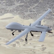
It’s looking like the Pentagon won't be able to afford lots of radically new unmanned planes, so General Atomics Aeronautical Systems has adopted a commonsense strategy: Why not convince military customers to improve the models they already have?

Built on speculation: Improved Gray Eagle's first flight July 26. (Credit: General Atomics Aeronautical Systems)
On the Air Force side, Pentagon intelligence chief Michael Vickers returned from a visit to the San Diego company last year supporting a proposal to retrofit Reaper planes with longer wings, wing-mounted fuel pods and heavier landing gear to support the additional weight.
Now it's the Army’s turn.
General Atomics spent internal research and development dollars building a longer endurance version of the Army’s Predator-inspired Gray Eagle. It's now preparing to demonstrate the Improved Gray Eagle, or IGE, in front of the Army later this year.
The Army is sure to be paying attention. The plane will be powered by an Alternate Heavy Fuel Engine the Army paid for as a potential upgrade to the Gray Eagle engines. Heavy fuel means diesel aviation fuel, rather than the gasoline that powered early unmanned planes. Heavy fuel is higher energy and easier to deliver to the field because so many jets and helicopters already use it.
The Army says it’s interested in the "overall improvement that IGE could potentially provide.” It also cautions that there’s no money in the current acquisition strategy for an Improved Gray Eagle.
General Atomics and the Army are just now in negotiations on a contract to start full-rate production of Gray Eagles, versions of which have been flying since 2008. General Atomics hopes to seal the contract this month.
The company flew the IGE demonstrator for first time on July 26 from its Flight Operations Facility in Palmdale, Calif.
The plane has a deeper belly than the existing Gray Eagles to carry 50-percent more fuel, plus it has an improved centerline hard point that can support either a 500-pound external fuel pod or a larger sensor.
General Atomics calculates that with the fuel pod the IGE should be able to fly for 45 hours in an intelligence, surveillance, reconnaissance configuration, compared to the currently marketed endurance of 25 hours.
Customers would have the option of dedicating some of the additional space for a damage tolerance computer or a traffic collision avoidance system.
Engineers went with a deeper fuselage instead of longer wings so that the planes wouldn't take up any more room on a crowded flight line.
General Atomics says it hopes “to go on contract with the Army for IGE production following a successful demo."