Features
DigitalGlobe: Thumbs-up for GeoEye Analytics

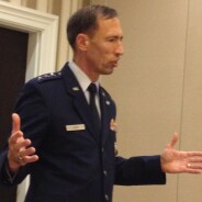
DigitalGlobe plans to retain GeoEye’s special-operations oriented predictive analytics unit, should regulators approve the merger of the commercial satellite firms, said Walter Scott, DigitalGlobe’s founder and chief technology officer.
“We think (GeoEye Analytics) is highly complementary,” Scott told Deep Dive in an interview at the GEOINT symposium.
")
Walter Scott, DigitalGlobe's founder and CTO. Credit: DigitalGlobe
DigitalGlobe, which would lead the merged imaging company, has its own analytics group, but Scott said there would be room for both DigitalGlobe’s Analysis Center and GeoEye Analytics.
DigitalGlobe provides unclassified expertise whereas experts from GeoEye Analytics are “embedded in the customer footprint” to work on classified projects, Scott said.
“We think that there’s a high degree of synergy there,” he added.
GeoEye Analytics, formerly known as SPADAC, combines satellite imagery with intelligence data to try to anticipate where IED planters, domestic criminals or fugitives like Uganda’s Joseph Kony might go next. GeoEye bought SPADAC in 2010.
One of the company’s human terrain analysts, Kevin Stofan, received the Lt. Michael P. Murphy Award in Geospatial Intelligence at the 2010 GEOINT symposium.
GeoEye CEO Matt O’Connell talked up GeoEye Analytics last month in an address to the Washington Space Business Roundtable group.
“We helped apprehend a rapist in Philadelphia, by okay, ‘Where has he struck in the past?’,” he said. “We just got a commendation from a British special forces unit because we helped find a bunch of raw materials that people had built into a cache. It was obviously for IEDs.”
After the talk, O’Connell told Deep Dive that demand is growing for the unit’s services, especially in the special operations world. “We’ve expanded the Tampa office because there’s so much work,” he said.
Clapper blasts Benghazi “politicking”

Director of National Intelligence James R. Clapper fell back on the words of an old friend to defend his handling of intelligence about the attack on the U.S. consulate in Benghazi, Libya.
Speaking at the GEOINT symposium in Orlando, Clapper recalled arriving back in Washington from Australia and “reading media clips about the hapless, hopeless, helpless, incompetent DNI, because I acknowledged publicly that we didn’t instantly have the God’s eye, God’s ear certitude about the event.”

Credit: U.S. Geospatial Intelligence Foundation
He was referring to a Sept. 28 statement from his office announcing that the community had shifted its thinking about whether the Benghazi attack was preplanned, a change that became fodder for Republican critics of the Obama administration.
Intelligence officials initially told the White House the attack was the result of a spontaneous demonstration. Newer analysis suggests it was “a deliberate and organized terrorist attack,” according to the statement.
In a talk that was at times caustic, sarcastic, and humorous, Clapper suggested that it was dangerous to inject election year politics into the intelligence process which is just that – a process.
He said an article published last week by retired Georgetown professor Paul Pillar should be instructive to the legislative and executive branches, and to “the fourth estate – the media.”
Clapper read aloud Pillar’s entire 455 word article posted Oct. 1 on the “The National Interest” website. The article makes the case that “hindsight is cheap,” but Clapper put special emphasis on this passage:
“The demand for an explanation that is quick, definite and unchanging, reflects a naïve expectation, or in the present case, irresponsible politicking.”
Later, during the question and answer session, Clapper said it might be time to set a term limit for his position. A fixed term “would be a good thing,” he said, if the country wants to keep the position “functionally apolitical.”
Clapper joked that he might need a new job after Jan. 21. “I’ll have both feet in assisted living,” he said.
Interview: Jump starting GEOINT apps

Job number one for Mark Riccio is to speed up the apps revolution promised two years ago by his boss, National Geospatial-Intelligence Agency Director Letitia Long. NGA has released about a hundred apps so far, but the agency wants as many as thousands out there on all three intelligence networks. Apps for counterterrorism; apps for disaster relief; apps for things no one’s thought of yet. Industry buy-in has been tough to get. Lots of software developers are doing just fine under the old model of meeting rigidly defined requirements. Riccio must sort this out in his role as director of application services within NGA's Online GEOINT Services Directorate. His solution? Gather industry reps in one room and start brainstorming. He spoke to Deep Dive about the Sept. 27 “Industry Outreach Day,” and what comes next. Excerpts below>>

NGA's Mark Riccio speaks to developers. Credit: NGA
Fear of change >> “This is something brand new, and there’s a lot of trepidation as we step forward on this because it hasn’t been done before. If I hadn’t encountered some of that skepticism, or some of the good hard questions that we got, I don’t know if we would have been pushing it far enough…I am very confident that we’re going to be able to succeed in this.”
Buy-in >> “Of the emails and communiqués I’ve gotten after that (industry day), I haven’t gotten any that said, ‘We’re not behind you. We don’t want to work with you. We don’t think we can get this done.’ A hundred percent, to a T so far, everybody says, ‘We want to work with you. This is something we can get done. Let’s kind of collaborate and figure out how we can move forward on this.’
Turnout >> “We had 263 discrete companies (at the industry day) and we are estimating that when all is said and done we had over 420 attendees.”
Next step >> “We don’t want this to be where we got everybody together, and then it’s months and months and months before you hear anything. We are ready to go and we are proceeding at a very expedient pace to get this (acquisition process) in place.”
Competition >> “Our directorate’s mission is to create the best user experience, and I think competition will enable that, and that’s what we’re interested in. This is a big opportunity for a much broader segment of the market to begin working with NGA.”
How many apps? >> “The intent is to spur the marketplace, and to spur the development community to help us fill that app store with hundreds if not thousands of different applications.”
Flexibility >> “The FAR (Federal Acquisition Regulation) offers a lot of capability to do things differently, to do things in a much more agile manner, and we’re going to be exploiting some of that capability.”
Rolling solicitation >> “It’s really different in the sense that instead of being super specific in terms of what we need, and then contracting specifically for those items, it’s more of a broad-based, open-based type solicitation, where we don’t want to be so specific that we hamper innovation.”
Exceptions >> “I think there’s going to be certain instances where we may get proscriptive. Maybe we’ll put something out that says, ‘NGA is interested in an app that does this,’ and we provide additional specifics. But the intent of the compensation model, as it’s (being) built, is to have that flexibility and the ability to cover situations like that.”
Payday >> ”A big part of what industry day was about is to develop a business-to-business application compensation model. And that’s really about publishing that speculative model for app development…It was made pretty clear at industry day that we’re still working on it.”
Innovation >> “We certainly don’t own all those good ideas, and we don’t want to put in place a mechanism that restricts us from enjoying the innovation that’s out there.”
No lemons >> “In the sense of multiple apps competing, just like there’s multiple weather apps, they all provide weather, but maybe some do it better. Maybe some are more pleasing, maybe the interface and utility and the use of that app is a little bit better. We’re not going to put any duds out there in terms of functions not working.”
User friendly >> “There’s a lot of different ways to build an app that shows a helicopter landing zone. The winner in a case like that is going to be the one that provides not only the validated output, but does it in a way that provides the best possible experience.”
Validation >> “If we’ve got an application that generates coordinates, does some kind of coordinate conversion, or gives one a heading, or computes slope, or something like that, we’re going to make sure that the output from that app is accurate and that it’s validated.”
Vendors can adapt >> “There’s a number of examples of traditional desktop software vendors who have made successful implementation of both existing technologies and new technologies within that [consumer app] type of market.”
Briefing Congress >> “We haven’t at this time, but it’s something we hope happens.”
OPINION: Take GPS spoofing seriously
FAA, airline industry should retain old-fashioned backups

In today’s cyber landscape, a terrorist posing as a passenger on a commercial flight couldn't easily open up his laptop computer and use GPS spoofing to deceive the flight crew about the location and direction of the plane. Ground-based radars and manual flight controls prevent false GPS readings from going undetected. However, spoofing could become a more serious risk as the U.S. rolls out the GPS-based Next Generation air traffic control system and begins unplugging those ground-based systems.
The threat of terrorists redirecting and manipulating GPS signals won’t be easy to solve, which may be why it isn’t often discussed in the context of NextGEN. But it is a consideration that must be made.
NextGEN is a navigation upgrade that’s being undertaken by the Federal Aviation Administration to replace World War II-era radar tower technology. The long-term cost savings projected from the multi-billion-dollar NextGEN investment are premised largely on shifting navigation and air traffic control to GPS readings, so that today's expensive ground-based navigation aids can be turned off. Airlines are also in favor of this shift because it will allow them to lighten their planes and improve fuel efficiency.
Without at least some of today's backup ground based systems, aircraft could become more vulnerable to GPS spoofing, just as ships and trucks are today. GPS readings collected by ships and trucks are sent to control centers without backups. Threat actors could spoof these locations and disguise the real position of a hijacked ship or truck. A ship with a dangerous payload, for example, could be steered undetected into a different port.
NextGEN could create similar vulnerabilities for airliners if the risk is not taken into account by retaining some of the old technology. In addition to retaining some analog systems, pilots and air traffic controllers would benefit from detailed training on how to detect spoofing and cope with it if it happens.
As a former airline pilot who was in the air on the morning of Sept. 11, 2001, I wondered if previous GPS spoofing incidents might offer lessons for our airline industry and other transportation sectors. I studied the issue in my role as a security analyst for Dynamic Research Corp., and I summarized my interpretations in the paper, "GPS Spoofing.” The paper describes my personal views about how Iranian officials might have been able to take control of a U.S. RQ-170 reconnaissance aircraft last December. Evidence in the public record indicates that threat actors were able to jam the encrypted communications signal from a satellite without breaking the encryption, giving them the ability to leverage an autopilot feature to manipulate the GPS signals.
Those techniques couldn’t easily be applied to airliners today because of the current safeguards. Air Traffic Control radars detect and track aircraft most of the way along their routes, except when planes are over the highest mountain ranges or far out over the oceans. As a backup to the GPS system, each cockpit is equipped with a VHF receiver that can be tuned to a specific VOR (variable omni range) station, similar to the way a car radio can be turned to an FM station. The crew can set and track a specific course that is displayed on an analog gauge. During landings, radio beacons and light signals are beamed from the ground to help assure pilots they are on the correct glide slopes, especially in low visibility.
If a threat actor jammed the GPS signal and tried to replace it with a spoofed reading, the pilots would know something was wrong.
As NextGEN is rolled out, the risk of GPS spoofing could be kept low by retaining some elements of that equipment. The recent loss of GPS-based unmanned vehicles shows that GPS spoofing is an emerging cyber threat that needs to be taken seriously not just in defense, but in civilian transportation industries as well.
Inside the DigitalGlobe, GeoEye merger
Proposed combo gets anti-trust scrutiny

"They saw blood in the water and struck," said an industry executive.
The confidential email that landed at GeoEye’s Herndon, Va., headquarters in June looked like checkmate in the company’s unexpected competition for survival against DigitalGlobe, its rival in the U.S. satellite imaging market.

Earthquake damage to the Port au Prince National Cathedral. Credit: GeoEye
Secret apps by next week

The National Geospatial Intelligence-Agency plans to complete the process of installing app stores on all three intelligence networks when it opens the secret version within the next week. Unclassified and top secret versions are already open.
All NGA has to do now is figure out how to fill the stores with apps.

Credit: National Geospatial-Intelligence Agency
The agency has published about a hundred geospatial apps produced under individual contracts. NGA doesn’t think that approach is financially sustainable or the best way to take advantage of private sector innovation.
But how can NGA fire up the software industry to deliver apps on its own initiative?
That was the topic of an unclassified “Industry Day” held today at the William Allder Auditorium inside NGA’s futuristic Campus East facility in Springfield, Va.
The auditorium was filled almost to capacity by industry officials, some of whom asked hard-hitting questions about the shift NGA is attempting.
Until now, NGA has spelled out and paid for exactly the kind of software it required to solve specific geospatial problems. Under the app model, NGA will give companies broad categories of apps, such as “Counterterrorism” or “Transnational Analysis.” Developers would create apps on their own dime, submit them to NGA for security and legal approval, and earn returns based on how well the apps perform for users who download them from the stores. The apps could be downloaded to smartphones, tablets or desktops, subject to security rules.
“The best athlete will win,” said NGA’s Mark Riccio, application services director in the Online GEOINT Services Directorate, a group established by NGA in February.
NGA is still working out exactly how to measure performance and pay the app developers. Last month the agency released a request for information seeking ideas for compensation models.
The conundrum is that important apps might only be used by handfuls of users, which means numbers of downloads alone can’t be the reward metric. User feedback also would need to be considered, and so NGA is looking at systems of star-ratings and payments for apps that move from bronze to silver to gold categories.
Some fees would come from downloads, but at the industry day NGA officials did not spell out how those fees would be paid. A soldier in a Stryker vehicle, for example, could not whip out a credit card, one attendee noted after the session.
Once that issue is resolved, much would the apps cost to download? In the question and answer session, one of the attendees brought up the example of Angry Birds, the app store game with versions ranging from free to 99 cents.
Jill O’Connor, an NGA contracting lawyer, said prices would take into account how many users are likely to need the app. Some could cost $100, others $400 or even more.
“I don’t think we’re limiting ourselves to the 99 cents,” O’Connor said. “For the ones that only a handful of people will use – tens of thousands of dollars?” she said.
As far as timing, NGA has set bold goals. Director Letitia Long has told staff she wants 75 percent of all apps to come from the industry, not NGA, by July 2013.
NGA also wants developers to produce functional apps within 60 days from concept to operation. The agency is setting up a process to approve them for inclusion in the stores within two weeks of submission, which in the commercial world is about how long Apple requires to approve iPhone apps.
The case for laser links

Lots of factors need to fall into place if General Atomics Aeronautical Systems is going to use lasers to move imagery off its unmanned planes a thousand times faster than is possible with the radio communications used today.
The critical missing ingredient for the company’s proposed laser comm demos is a four letter word -- cash.
General Atomics is openly soliciting “government support” to turn its laser blueprint into hardware that could be tried out on unmanned Reaper planes. At this month’s Berlin Air Show, the company sought to help make the case by decloaking a teaming agreement it signed quietly months ago with the German company Tesat Spacecom, a laser comms pioneer.

The companies think they can use lasers to beam imagery from unmanned planes at a clip of about 2 gigabits per second, or “several hundred to a thousand” times faster than is possible with the radio frequency satellite links on the planes today, said Michael Perry, the General Atomics vice president for laser electro-optics.
If the companies can find a sponsor, one of their first steps would be to beam imagery from an unmanned Reaper to a satellite in low Earth orbit. Ultimately, though, they want to send the laser 22,500 miles into space to a communications satellite called Alphasat. It is scheduled for launch in 2013 to a position over Europe, Africa and the Middle East for the European Space Agency and mobile communications giant Inmarsat. Alphasat’s main job will be to serve Inmarsat’s BGAN mobile comms customers, but it also will carry unrelated, or hosted, payloads. One of these happens to be a demonstration laser communication terminal built by Tesat.
If the demo goes as planned, the Reaper imagery would arrive by laser at the Tesat terminal, but it would be relayed to ground sites via multiple ka-band radio frequency transmissions.
General Atomics engineers are not the first experts to think about using lasers for faster communications. Lots of research has been conducted by DARPA and the Air Force Research Lab, but General Atomics wants to tie the technologies into a new application: “To our knowledge, this would be the first laser comm capability on a UAV,” Perry said.
If it works, flight crews in ground control stations in the U.S. would be able to view more terrain on their screens, and so would intelligence analysts at fusion sites.
General Atomics hasn’t said which agencies it is pitching the demos to, but Pentagon officials fret about the readiness of networks and communications links to handle imagery from new multi-camera wide area surveillance systems that take city-sized snapshots several times a second. Reapers carry the Gorgon Stare wide area imaging pods. They will probably end up carrying the even wider area Argus-IS systems in development by BAE Systems as the next version of the Gorgon Stare imaging system provided by Sierra Nevada Corp.
Most unmanned planes are still equipped with full motion video cameras that deliver soda-straw views just meters across.
For General Atomics, some factors have fallen into place toward the laser demos. The company has received permission from the State Department to share data and expertise with Tesat, Perry said. That makes it possible for the companies to collaborate on building hardware. The companies are refining their blueprint now that they are free to talk. If a sponsor is found, most of the equipment would be built by General Atomics; Tesat would provide some critical components.
The biggest technical challenge will be squeezing the communications package into a housing small enough to ride on the aircraft’s fuselage without disrupting its aerodynamics.
The company has tested the laser housing on a Reaper with good results, Perry said. “The main purpose of the experiment was to show it was aerodynamically stable and did not have a negative impact on the endurance – and both those things were shown,” he said.
The remaining work should be doable.
“What we’re talking about is something that is a derivative of systems that Tesat has done in the past,” he said. “This is not [about] looking for some kind of fundamental breakthrough at this point.”
Army Lt. Gen. Michael T. Flynn
Director, Defense Intelligence Agency

Since: July 24, 2012
Nickname: Mike
You might not know: Flynn found a way to take part in the 1983 Grenada invasion, prompting Director of National Intelligence Jim Clapper to dub him "the second lieutenant who went to Grenada on his own.”
(more…)
Air Force explains automation delay
A popular metaphor in Air Force intelligence circles has analysts drowning in a sea of data. To hear the service's intelligence chief tell it, the service now risks drowning in something else: A sea of proposals for how to handle the video and signals intelligence beamed down by 57 unmanned aircraft patrols and round-the-clock flights by MC-12 Liberty turboprops.

Lt. Gen. Larry James, Air Force deputy chief of staff for intelligence
Air Force Lt. Gen. Larry James defended the methodical preparations the service has been making toward automating aspects of its notoriously labor-intensive processing, exploitation and dissemination, or PED, chain.
The Air Force Research Lab has been assigned to act as a "filter because frankly there are a lot of people out there with ideas for a product which may or may not work," James told an audience at the Air Force Association conference in Maryland.
Industry officials, including at least one in the conference audience, are growing frustrated that the service's top generals began publicly calling for automated tools more than a year ago but have yet to match those calls with a process for setting requirements and funding purchases of the tools.
James said an experimental processing system has been set up at an AFRL site so "we can actually take those tools and operate them on the system, with an analyst in the loop, and understand, 'Is this something that's worthy for us to invest in?'"
An adequate science and technology and rapid acquisition process is now in place, James said. Meeting with reporters later, he added that a "roadmap" for purchasing the tools would be established by the intelligence surveillance and reconnaissance review that's been underway for about a year and a half for Air Force Secretary Michael Donley.
"That should be done by the end of the year. Then we'll have a pretty good idea, of, 'Okay this is where we need to be in 2015, this is where we think we'll be in 2018,'" he said.
James made clear that even as the U.S. prepares to hand over the lead to Afghan forces, the service expects to collect more and more video and signals intelligence over Afghanistan and other hotspots.
The Air Force has been holding steady at 57 combat air patrols of Predator and Reaper planes over Afghanistan and "other parts of the Mideast," he said. The pause in growth was necessary: "We've been in the middle of reconstituting our training program, reconstituting our weapons school," he explained.
In November, the holding pattern will end, and the service will begin adding patrols to reach about 65 by May 2014, and "ultimately the capability to surge to 85 combat air patrols."
It's not just the number of patrols that's creating the desire for automation, James said. A big driver will be a next generation version of the Gorgon Stare wide area camera system called ARGUS-IS, short for Autonomous Real-Time Ground Ubiquitous Surveillance-Imaging System.
"The data content and size is not slowing down," James said.
Big data is not always easy to work with either. James said the service has had technical trouble moving Gorgon Stare wide-area motion imagery from location to location, but that he thinks the Defense Information Systems Agency has solved the problem.
Aerostats as swarming boat spotters

A time honored strategy for reinvigorating a defense project in Congress is to tie it to an issue on the minds of lawmakers.
That's Raytheon's strategy for saving its radar-equipped JLENS aerostats, known formally as Joint Land Attack Cruise Missile Defense Elevated Netted Sensor systems.
Unless Congress or the Pentagon's acquisition chief steps in, the Army will wrap up all of its JLENS work in 2014, aside from a possible "Combatant Command Exercise" somewhere in the U.S. before 2017. Even that exercise looks problematic, with Senate appropriators balking at paying $30.5 million in 2013 toward it. The project could end with just four aerostats, no real world test and $2 billion expended.

A JLENS can be unreeled to 13,000 feet to see hundreds of kilometers.
Raytheon hasn't given up hope for continuing into production with JLENS, which is where the issue on the minds of lawmakers comes in.
As the term "cruise missile" in the name suggests, the Army kicked off the JLENS project in 2006 mainly to show how radars could stare down from aerostats and track terrain-hugging missiles, helicopters and small planes.
With lawmakers flocking back to town and tensions simmering with Iran, Raytheon is pointing to JLENS as part of the answer to the worry that small boats could swarm around U.S. warships, particularly at strategic choke points.
If you were to guess that means the Strait of Hormuz, Mark Rose's eyes will widen and you'll be pretty sure you detect a nod. Rose, a 32-year Raytheon employee, directs the company's JLENS work.
"Swarming boats have been in the plan all along, but it's receiving more urgency now given the threat sets in the world," he tells Deep Dive.
In June, Raytheon laid the groundwork for the case by motoring two small inflatable boats over Utah's Great Salt Lake. It wasn't a swarm, but it was good enough to test JLENS' ability to track small boats in motion. JLENS has tracked large numbers of cars on distant highways, which makes Raytheon confident the aerostats can handle lots of boats too.
Swarm conjures images of boats racing toward U.S. ships, but actually the bigger challenge for a Doppler radar is to track slow moving things. JLENS did better than specifications when engineers tested how slowly they could move the boats and still keep track of them, an Army official says.
At the moment, there are no plans to send JLENS to any distant hot spots, which is not to say that hasn't been considered. There was a plan to send JLENS to someplace in the Central Command area but the idea was shelved more than a year ago out of concern that the deployment could be seen as provocative.
"It's a pretty big step when you put a football field-length airship up in that region," the Army official says.
In Congress, Raytheon could be onto something with its new focus on swarming boats. House authorizers, for instance, want the Navy to field a 100 to 200 kilowatt laser to defend ships against drones, cruise missiles and also "fast attack craft threats."
"The beauty of this system is that you can see things from so far away that you have lots of time to make decisions," Rose says. Plus, by flying for 30 days at a time, JLENS could also map patterns of life on land and sea, he adds.
Each system consists of two, 74-meter-long aerostats. One is equipped with a VHF-radar for surveillance. The other carries an X-band fire control radar for locking weapons onto targets. The radar readings are sent to the ground via fiber optic cables protected inside each aerostat's Kevlar-reinforced tether. Operators feed them into networks, including the Navy's Cooperative Engagement Capability network.
JLENS is designed to detect and track small aircraft, boats or trucks out to a range of 512 kilometers.
Rose says that if he had his druthers, the Pentagon would send a JLENS to a location where it could track objects both on land and at sea. Ultimately, Raytheon hopes the Pentagon will reverse course and issue a production contract.
If that happens, JLENS will have bucked a troubled history. In December 2010, the Pentagon reported that its unit cost had risen 17.88 percent, which amounted to a "significant breach" of the Nunn-McCurdy cost control law. One factor was bad luck. In September, a JLENS was riding out a tropical storm on the ground in Elizabeth City, N.C., when another aerostat crashed into it, seriously injuring a worker and damaging the JLENS beyond repair. Elizabeth City is the manufacturing hub of TCOM, the lighter-than-air specialists who made the JLENS hulls for Raytheon.
Bad luck, shifting Army priorities and radar development delays prompted the Pentagon to scrap plans to purchase 16 JLENS systems. The decision left just the two systems now in the inventory, which equates to four aerostats. The reduced buy sent projected unit costs upwards and triggered a full-on Nunn-McCurdy breach that required the Pentagon to recertify the program to Congress. The recertification has had limited impact so far. The Pentagon continues to plan for the exercise but has no plans at the moment to procure more of the aerostats.
Rose says Raytheon has figured out how to cut production costs by incorporating components from the company's contributions to the anti-missile Terminal High Altitude Area Defense system, or THAAD, which spots missiles and knocks them down high in the atmosphere. "We've been able to reduce the cost 30 percent by recognizing the commonalities," Rose says. The strategy allows Raytheon to negotiate higher volume purchasing agreements with component suppliers.